A Partnership of UConn and Eversource
Eversource Energy Center
Author: National Challenges for Energy Pipelines Seminar
Where: Alumni Center;
When: Aug 30 at 5:15-6:15pm
Seminar title: “National Challenges for Energy Pipelines”
Speaker: Robert Smith
The presentation and discussion will cover the importance of energy pipelines to our country and illustrate that a number of integrity challenges must be addressed in keeping these systems safe. The presentation will also touch upon how research and development is bringing solutions to the market and about workforce planning opportunities in pipelining.
Robert Smith
Robert graduated from the Pennsylvania State University in 1997 with a BS in Petroleum and Natural Gas Engineering. He coordinated and managed the offshore pipeline and human factors research program at the Bureau of Safety and Environmental Enforcement (formerly U.S. Minerals Management Service) from 1997 to 2003. Since 2003 and currently, he is the Senior R&D Program Manager and leads several strategic initiatives for the Pipeline and Hazardous Materials Safety Administration.
Author: GTI Workshop: Remote Sensing and Reliability of Gas and Electrical Infrastructure Systems
Location: Eversource Energy Center, University of Connecticut UConn-Alumni Center, 2384 Alumni Drive, Storrs, CT
Date: Thursday, August 30th, 2018
The Gas Technology Institute (GTI) and the Eversource Energy Center at the University of Connecticut (UConn) are coordinating a workshop to identify the state-of-the-art remote sensing research and technology for solving real-world challenges to natural gas and electrical infrastructure relating to natural forces.
The workshop will discuss the risks to natural gas, electrical, and other utilities’ infrastructure and their resiliency against external natural forces such as earth movement, landslides, floods/flash floods, weather events, wind, and fire. The workshop will explore recent advancements in remote sensing technologies for use in identifying risks to utility infrastructure and opportunities for enhancing their resiliency.
Introduction:
Natural forces damage is one of the main challenges to safe operations of natural gas pipelines and electrical transmission power lines. Reported data by the U.S. DOT Pipeline and Hazardous Materials Safety Administration (PHMSA) has shown that natural forces are a root cause of significant gas pipeline incidents. Also, data reported from the US Department of Energy, Energy Information Administration show significant increase in power line disturbances caused by weather related incidents.
Remote Sensing technologies such as acoustic, radar, laser, and multispectral imagery systems are continuously being introduced on stationary, vehicular, aerial and space-based platforms with potential uses in Right-of-Way (ROW) monitoring and assessment of the risks to natural gas and electrical grid infrastructure due to natural forces. The workshop is intended to identify these technologies and key issues related to their use, identify research gaps and development needs, and ultimately develop a roadmap for their implementation.
The workshop is structured to be both informative and collaborative. Speakers from the U.S. DOE, DOT-PHMSA, academia, utilities, and professional organizations, and industry are invited to present and participate in the development and implementation of remote sensing technologies in risk management of these systems.
The dialogue among the attendees will provide insight on the opportunities and technology gaps and the outcome of the workshop will formulate a roadmap of the development needs of the focus areas identified in the Workshop Agenda.
Scope:
The workshop topics cover various applications of remote sensing technology in the risk management and reliability of natural gas and electrical infrastructure. Examples of topic areas to be discussed in the workshop include, but not limited to, the following:
Remote Sensing Technology Applications:
- Applications of LiDAR, hyperspectral, multispectral, and thermal imagery from UAV and other airborne platforms in natural gas and electrical infrastructure.
- Monitoring of earth movement, landslides/debris flows, and flash flooding for Integrity management and post-event evaluation of infrastructure systems.
- Safety and reliability of electrical power line systems and its mitigation procedures against the risk of wildfire and other extreme weather events.
Data Management and Risk Assessment:
- Automated detection algorithms and post-event evaluations of natural force threats.
- Predictive Analytics using multiple data sources to sort risks of natural forces
- Predicting gas leak migration and mitigation from remote sensing measurements
Contact:
Gas Technology Institute:
– Khalid Farrag, Ph.D., P.E. | Khalid.farrag@gastechnology.org | 847-768-0803
Eversource Energy Center, University of Connecticut:
– Jason Parent, Ph.D. | jason.parent@uconn.edu | 860-486-4169
Workshop Agenda:
Date: Thursday, August 30, 2018 – 8:00 AM- 5:00 PM
Location: Eversource Energy Center, University of Connecticut
UConn-Alumni Center, 2384 Alumni Drive, Storrs, CT
Overall Objective: Identify current state of the technology, development gaps, implementation needs, and provide recommendations on remote sensing monitoring of natural force threats.
SESSION 1: Regulatory and Industry Presentations (8:00 AM- 11:30 AM)
Introduction and Summary of Workshop, GTI-Eversource
Research Activities and Needs – Regulatory Perspective, U.S. DOT PHMSA
Remote sensing technologies (LiDAR, hyperspectral, multispectral, thermal imagery, and other) in risk assessment
Utilities Implementation and Needs
– Natural force threats, monitoring and research needs, SoCal Gas
– Aerial LiDAR data acquisition and use for ground movement detection, PG&E
– Implementation of Remote sensing technologies, Eversource
SESSION 2: Technical Presentations (12:30 PM-3:30 PM), topics:
Industry Focus Areas, Research and Developments
Research and Application of remote sensing in ROW monitoring, U.S. DOE, ARPA-E
Post-event evaluation of earth movement, landslides/debris flows, and flash flooding and other natural force threats
Risk Analysis and Threat Mitigation of natural gas transmission systems and their threat-mitigation procedures.
Automated detection algorithms and post-event evaluations of natural force threats,
Electrical power lines risk assessment against extreme weather conditions
SESSION 3: Group Discussion: Developments and Applications Road Map (3:45 PM– 5:00 PM)
[Adjourn]
All this information can be found in a pdf here.
Author: Harnessing Data Analytics to Model Solar Energy Power Outputs
Author: Insights into Cyber Security Investments
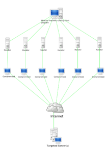
In today’s interconnected world, data breaches affect hundreds of millions of U.S. customers of banks and services yearly. Hacking scandals at major institutions make news because of the headaches they cause for both business stakeholders and their customers, and demand is growing for data protection technologies. To address the challenge of protecting the energy infrastructure from hacking, Paul Borochin, assistant professor in the School of Business at the University of Connecticut, is collaborating with the Eversource Energy Center to develop economic measures of the value of cyber security and to investigate the investment values of the Eversource Energy Resiliency Initiatives in Connecticut.
Investment in cybersecurity is a key to electric grid resilience, security, and economic prosperity. Many options are available for protecting against unauthorized access to data in a system, and third parties sell a variety of both existing and customized products. No clear standard has yet been set, however, for how much customers need to invest in the protection. This is where Professor Borochin’s analysis comes in. By measuring the expected benefit of protections against its cost, a business can invest in just enough cyber security to cover the bulk of its expected risks, thus minimizing the cost that is passed along to customers.
The calculation of risk is the main consideration when determining the expected value of investments made by Eversource Energy, and it involves quantifying the likelihoods of losses and exposures. An essential part of Professor Borochin’s work is mapping areas within the power grid in Connecticut that might be vulnerable to hacking to help Eversource stakeholders design optimal cost–benefit strategies.
According to Professor Borochin, “The challenge we face as economists concerned with capital budgeting is that, while we can attach dollar figures to the benefit of investment, those figures are never going to be completely certain. The point of the techniques we bring to bear, such as the real options framework that models the ability to update investment decisions, is to try to get an estimate specifically in the presence of uncertainty. You end up with a dollar figure, plus or minus some error.” Professor Borochin incorporates this uncertainty when conducting his analysis.
In support of these economic evaluations, Professor Borochin is collaborating with Eversource Energy Center electrical engineers who are creating a software emulation of the Connecticut power grid to test cyber security prevention methods and assess their economic consequences. This research is expected to help protect the Connecticut power grid from cyberattacks originating both at home and abroad.
Paul Borochin received his PhD in finance from the Fuqua School at Duke University and his BS in finance and statistics from the Wharton School at the University of Pennsylvania. Besides cyber security investments, Professor Borochin’s research interests include institutional ownership, applications of asset pricing theory, corporate governance, information asymmetry, and corporate events and policies.
Author: Workshop: Grid Modernization & Distributed Energy Resources
Location: University of Connecticut, Alumni House, Great Hall, 2384 Alumni Drive, Storrs, CT 06269
Date: June 14-15, 2018
Eversource Workshop Official Announcement
The Eversource Energy Center at the University of Connecticut (UConn) is hosting a workshop aimed at identifying key challenges and potential solutions related to the modernization of electric grid. The focus will be on enhancing stability and resiliency of the grid in an environment of increasing penetration of intermittent renewables and other Distributed Energy Resources (DERs) as well as other potentially disruptive factors such as climate, extreme weather events and the widespread adoption of electric vehicles.

Image Source: https://ilbusinessdaily.com/stories/511284886-illinois-lauded-on-national-level-for-grid-modernization
The workshop will explore possible solutions by considering the complex interdependencies of technology, economics, regulation and energy demand. Also considered will be the relationship between natural gas and the electric grid. Included will be a discussion of Virtual Power Plants (VPPs), where the utility controls and synchronizes multiple DER technologies such as renewable power generation sources (PV, hydropower and wind), micro Combined Heat and Electricity (mCHE) devices, pump-hydro, and battery storage. The workshop will also consider the dynamics of energy demand and supply, and discuss implications of the above technological solutions under alternate futures and extreme weather and security based outage events.
The workshop outcome will be a report summarizing research gaps and development needs, and ultimately a roadmap for their implementation.
Topics:
Workshop Session I – Identifying the challenges
In this session we will identify and explore the challenges electric utilities have maintaining stability and enhancing resiliency in response to intermittent renewables, peak loads and ramp-up effects, and other stresses on the grid caused by load profiles, electric vehicles, climate, and other factors.
We will also discuss how these conditions are expected to change over time, and the potential impact of these changes on the grid.
Workshop Session II – Identifying the technologies
In this session we will begin by identifying the current state of technology for addressing these challenges, and then explore the leading technologies that can address these challenges going forward.
The focus of the discussion will be to understand the costs and risks associated with the widespread deployment of these technologies, including social acceptance and the capacity to include Low- and Medium-Income consumers in the adaptation of DER solutions. Included in the discussion will be an overview of different DER-based solutions, including mCHE, pump-hydro, and batteries, and what role a dispatchable network of such technologies could play in addressing the challenges. A few case studies will be presented.
Workshop Session III – Potential solutions and gaps
Session III will focus on identifying potential solutions, and where there are gaps in research or methodologies for understanding and evaluating them. With the inherent complexity and interdependency of the various technologies, economics, and regulations that make up the electric grid, as well as the relationship between the electric grid and natural gas, robust methodologies are essential for finding optimized solutions.
This session will include a discussion of a virtual power plant (VPP) approach, where the utility controls and synchronizes multiple distributed energy resource (DER) technologies, as well as the Distributed Generation (DG) models currently being used in Europe and how similar models might apply here.
By identifying the gaps in research and methodologies for utilities to evaluate potential solutions, we will be able to ultimately develop a roadmap for their implementation.
Target Attendees:
• Electric and Natural Gas Utility managers and planners.
• Professionals in the energy industry, including Energy Project Developers and VPP software providers.
• Utility Regulators.
• Academics interested in the technological, economic, regulatory, and social challenges of energy and energy distribution.
Agenda:
Day 1 (Thursday, June 14th)
11:30 – 12:00 Registration
12:00 – 12:15 Opening Session – Keynote Speaker [Jennifer Schilling, Grid Modernization Director, Eversource Energy]
12:15 – 1:15 Luncheon and Keynote Speaker [Katie Dykes, Chair, CT PURA]
1:15 – 2:30 Workshop Session I – Identifying the challenges
2:30 – 2:45 Break
2:45 – 3:15 Summary I – Challenges
3:15 – 3:35 Keynote speaker [Walter Rojowsky, Manager, Distributed Grid Advisory Team, ICF International]
3:35 – 3:55 Keynote speaker [Dan Bradley, Managing Director, Navigant]
3:55 – 5:15 Workshop Session II – Identifying the technologies
5:15 – 5:30 Break
5:30 – 6:00 Summary II – Technologies
6:00 – 7:00 Social
7:00 – 9:00 Dinner / Keynote Speaker [David Owens, Retired Executive Vice President, Edison Electric Institute]
Day 2 (Friday, June 15th)
8:00 – 8:20 Breakfast/ Opening Session – Keynote Speaker [Watson Collins, Technical Executive, EPRI]
8:20 – 8:40 Keynote speaker [Ray Samuels, Senior Vice President, DBS Power & Energy]
8:40 – 9:00 Keynote speaker [Jeff Nehr – Vice President, Production & Business Development, Peoples Gas]
9:00 – 10:30 Workshop Session III – Potential solutions and gaps
10:30 – 10:45 Break
10:45 – 11:15 Summary III – Potential solutions and gaps
11:15 – 11:30 Closing remarks & Next Steps
11:30 – 14:00 Steering team meeting & Lunch
Workshop format:
Workshops will be comprised of roundtable discussion groups of 8-10 attendees and a coordinator who will introduce the topic and facilitate the discussion. After each session, the coordinators from each group will summarize the key points and present them to everyone.
Contact:
Prof. Emmanouil Anagnostou | manos@uconn.edu | 860-486-6806
Eversource Energy Center, University of Connecticut
Author: World-Renowned Meteorologist Urges Engineers to Include the Human Factor in Climate Change Solutions
Scientists and engineers must take greater account of human perspectives in their projections if society is to avoid collapse from climate change, a prominent meteorologist and professor of atmospheric and oceanic science recently told UConn engineering students and faculty.
The April 13 visit of the University of Maryland’s Distinguished Professor Eugenia Kalnay was co-sponsored by the Eversource Energy Center (EEC) and the Environmental Engineering Program (ENVE) to coincide with UConn’s Metanoia, a university-wide initiative on the environment for Spring 2018. Kalnay, who in 1971 was the first woman to receive a doctorate in meteorology from MIT, today serves on the Scientific Advisory Board to the United Nations and is a recipient of the International Meteorological Organization Prize (2009), among other important honors in her field. Widely regarded as a weather science pioneer, Kalnay is one of the originators of HANDY (Human and Nature Dynamics), a model representing the interaction of human dynamics and the environment that prompted controversy when first published in 2014.
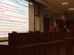
In an informal discussion with undergraduate students in the ENVE’s Environmental Modeling class, Kalnay cited the unsustainable rate at which human population is growing, which will soon result in consumption exceeding what natural resources can produce. This kind of demographic explosion has led to repeated collapses of societies throughout history, Kalnay said, and the Earth’s climate and environment are now more sensitive to human decisions and policies than in the past, when populations were much smaller relative to the available resources.
In a later round table discussion and a seminar entitled “Modeling Sustainability: Need to Couple Earth and Human Systems Models,” Kalnay explored with EEC, ENVE and Atmospheric Science Group (ASG) faculty and graduate students the chronological advances in modeling, from the purely atmospheric to the fully coupled multicomponent Earth system models, that form the scientific basis on which the Intergovernmental Panel on Climate Change (IPCC) generates climate change scenarios. Despite being so comprehensive, the models are not yet fully coupled with human models, Kalnay said, which could have large impacts on climate projections.
The seminar ended on an optimistic note, as Kalnay presented possible future scenarios in which intelligent geoengineering experiments are carried out to harness solar and wind energy to completely replace fossil fuels. In the Sahara Desert, she suggested, such efforts could potentially increase vegetation and reverse the desertification trend toward a greener region in the tropics. Estimates from her team’s model indicate this is feasible, she said.
Author: Voices from the ground: Exploring Wood Recovery Opportunities
Author: Administrative Services Assistant 3 (UCP 4)
The Eversource Energy Center is seeking applicants for the position of Administrative Services Assistant 3, UCP 4. This is a 12-month, full-time appointment. The successful candidate will serve as a point of contact for the Eversource Energy Center and will perform administrative and financial functions for the Center with funding from private, state, federal grant and contract sources.
DUTIES AND RESPONSIBILITIES
- Maintains and monitors Center and grant budgets; review transactions for accuracy, completeness and compliance with regulations, policies and procedures; monitors and approves expenditures; processes fiscal paperwork.
- Assist faculty Principal Investigators (PI) for grant post award to monitor budgets and ensure compliance with regulations and policies at the University, state and federal levels as well as the requirements of the Sponsored Programs Services (SPS) and funding agencies.
- Responsible for making all necessary arrangements for meetings, conferences and travel; arranges for and implements, as directed, conferences, seminars, committee meetings, assisting as required.
- Record encumbrances and expenditures to process all necessary paperwork, including payroll records, purchasing, disbursements, travel (pre and post trip), following up to resolve problems as they arise.
- Prepares regular financial statements on the condition of the Center and producing timely and accurate financial information, including budget projections and analysis.
- Performs office management duties; directs the workflow and supervises the processing of administrative and personnel paperwork; reviews paperwork for accuracy and adherence to policies and procedures.
- Assists director, manager and others in resolving budget and other business problems related to the Center operations.
- Perform related duties as required, including but not limited to the following: take and transcribe all minutes for Center-related meetings; initiate special payroll authorizations (SPAR), J1 and H1B visa applications; compose offer letters and payroll authorizations for individuals tied to Center accounts; process paperwork for unit’s financial transactions, including Procard purchases; and place orders with vendors and follow up to assure timely delivery.
- Schedules appointments and meetings for director.
- Review administrative and internal operation procedures to implement operations and/or fiscal policies.
- Transmits authoritative information and serves as a resource to students and others regarding fiscal and administrative policies and procedures governing the Center.
- Independently composes, prepares and/or edits standard correspondence and reports containing information that requires thorough knowledge of policies, procedures and data sources.
- May represent director to other University offices, the public or outside organizations to gather or transmit information that affects operations of the Center.
- As needed or assigned, may be responsible for special short term or ongoing projects that require planning, coordination and supervision.
MINIMUM QUALIFICATIONS
- Bachelor’s degree or equivalent combination of education and experience including 4-8 years’ experience in a progressively responsible administrative position.
- Demonstrated knowledge of fiscal and/or accounting functions of an organization with multiple fund sources
- Experience with electronic financial systems and spreadsheets
- Strong interpersonal skills and ability to work independently and effectively with staff and administrators
- Excellent time management and organizational skills; demonstrated accuracy and attention to detail
- Ability to contribute and participate as a team member;
PREFERRED QUALIFICATIONS
- Knowledge of KFS, Infoed, or Microsoft Office products
- Previous experience in a university or college setting dealing with fiscal functions
- Experience working effectively and efficiently with multiple departments
- Demonstrated ability to clearly communicate both verbally and in writing.
APPOINTMENT TERMS
This is a permanent full-time position. Salary will be commensurate with training and experience.
TO APPLY
Interested applicants, please upload a cover letter, resume and contact information for three professional references via UConn Jobs, www.jobs.uconn.edu, Staff Positions. Employment of the successful candidate will be contingent upon the successful completion of a pre-employment criminal background check. (Search #2018482)
This job posting is scheduled to be removed at 11:59 p.m. Eastern time on April 11, 2018.
All employees are subject to adherence to the State Code of Ethics which may be found at http://www.ct.gov/ethics/site/default.asp .
The University of Connecticut is committed to building and supporting a multicultural and diverse community of students, faculty and staff. The diversity of students, faculty and staff continues to increase, as does the number of honors students, valedictorians and salutatorians who consistently make UConn their top choice. More than 100 research centers and institutes serve the University’s teaching, research, diversity, and outreach missions, leading to UConn’s ranking as one of the nation’s top research universities. UConn’s faculty and staff are the critical link to fostering and expanding our vibrant, multicultural and diverse University community. As an Affirmative Action/Equal Employment Opportunity employer, UConn encourages applications from women, veterans, people with disabilities and members of traditionally underrepresented populations.
Author: How Do Precipitation Error Characteristics Affect The Simulation of Streamflow
The hydrologic application of precipitation estimation from remote sensing is a promising way to assess streamflow variability and its downstream impact for ungauged basins. Compared to conventional ground-based observational networks (i.e., rain gauge, meteorology station, weather radar), satellite remote sensing is uninhibited by terrain and can provide consistent precipitation measurement at fine space-time resolution (as fine as 0.04°/half-hourly). This is particularly meaningful for catchments characterized by complex terrain that are often susceptible to hydrometeorological hazards (e.g., flood, debris flow, landslides) induced by heavy precipitation and its interaction with catchment geomorphic characteristics.
Current satellite precipitation retrieval algorithms are based on the high-spatiotemporal-resolution observations in the visible–infrared (VIS–IR) spectrum from geostationary (GEO) satellites and the active and passive microwave (MW) sensors deployed on low-Earth-orbiting (LEO) satellites. The VIS–IR techniques have high sampling frequency (15-min/3–4-km, 1-km VIS) but retrieve precipitation indirectly based on cloud-top brightness temperatures. On the other hand, PMW techniques physically link the signal received by the satellite sensors to the size and phase of the hydrometeors present within the observed atmospheric column, but uncertainties arise from their low observational frequency and large sensor field-of-view areas.
It is deemed that precipitation retrievals from either VIS–IR or MW, or the combination of both sensors, suffers from noticeable errors compared to ground-based measurements. A common practice to improve the consistency of remote sensing-based product to ground-based measurements is to merge these two sources. But this is limited by the available number of reliable ground-based networks, which are scarce in some regions of the globe. Thus, to ensure meaningful hydrologic simulations by incorporating satellite remote sensing precipitation with the hydrologic model, it is necessary to understand the products’ error structure and their propagation characteristics in hydrologic simulations.
We set up a hydrologic model for three nested catchments (Swift, Fishing and Tar) of the Tar river basin in North Carolina, USA, with a drainage area of 426 km2, 1374 km2 and 2406 km2, respectively. 160 rainfall-runoff events over the catchments from 2003–2010 were selected as the simulation targets. Eleven quasi-global satellite precipitation products were evaluated with respect to a radar- and gauge-based product in terms of their accuracy in capturing the intensity of event rainfall and runoff.
The eleven satellite precipitation products come from four algorithms. The first two products are from the Tropical Rainfall Measuring Mission Multi-satellite Precipitation Analysis (TMPA). A near-real-time (Trt) and a gauge-adjusted version (Tg) of TMPA were used in the study. These 3-hourly products are at 0.25 °spatial resolution.
The Precipitation Estimation from Remotely Sensed Information using Artificial Neural Networks (PERSIANN) product is another near-real-time product (Prt) considered in the study. A high-resolution version (HPrt) and a gauge-adjusted version of the near-real-time PERSIANN (Pg) were also considered. Prt and Pg are in 0.25°/3-hourly resolution, while the HPrt is 0.04°/hourly.
Also used were the National Oceanic and Atmospheric Administration Climate Prediction Center’s morphing technique (CMORPH) product available at resolutions of 0.25°/3-hourly and 0.072°/half-hourly, abbreviated as Crt and HCrt, respectively. Gauge-corrected versions of these two products, denoted as Cg and HCg, were also included.
Finally, we included the Global Satellite Mapping of Precipitation’s (GSMaP) version 5 Microwave-IR Combined product for our analysis. Similarly, a near-real-time version (Grt) and its gauge-adjusted counterpart (Gg), were used. The two products are hourly and at 0.1° resolution.
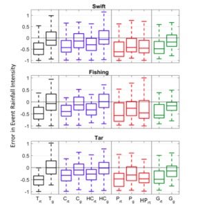
The distributions of mean relative error in event rainfall intensity for all events are demonstrated by boxplot in Figure 1. The figure shows that most of the satellite precipitation products, especially the near-real-time ones, tend to underestimate the rainfall intensity. The gauge-adjusted and higher resolution counterparts show medians of error much closer to zero for all the basins. Product-wise, the high-resolution gauge-adjusted CMORPH outperforms the others.
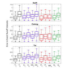
Mean relative error in event runoff intensity for all events are shown in Figure 2. The satellite product–driven flow simulations show underestimation as to the intensity. Similarly, the gauge-adjusted and high-resolution products are characterized by medians closer to zero than the corresponding near-real-time ones. The medians of error derived from the gauge-adjusted TMPA and high-resolution CMORPH outperform the others in most of the occasions.
To sum up, we found that the satellite precipitation products underestimated the intensity of rainfall and runoff of the events examined in this study. The gauge-adjusted and high-resolution products yielded lower error magnitudes than the corresponding near-real-time and coarse resolution counterparts. This indicates the benefit of higher resolution and the usefulness of merging with ground-based observations.
These findings are described in the article entitled Decomposing the satellite precipitation error propagation through the rainfall-runoff processes, recently published in the journal Advances in Water Resources. This work was led by Yiwen Mei, Emmanouil N. Anagnostou, Xinyi Shen and Efthymios I. Nikolopoulos from the University of Connecticut.
