A Partnership of UConn and Eversource

Eversource Energy Center

eversource-txt-logo

3-D Imaging for Modernization

The U.S. power grid is the largest interconnected machine on earth, with over 9,000 electric generating units connected to over 300,000 miles of transmission lines. Eversource operates over 4,200 miles of this transmission system and over 72,000 pole miles of distribution lines across Connecticut, Massachusetts and New Hampshire.

With air-and ground-level laser technology, Eversource and UConn are capturing hundreds of thousands to millions of data points in a pilot study in Greenwich, Connecticut. The result will be a three-dimensional picture of the overhead electric delivery infrastructure and surrounding trees. This study area is a pilot for combining 3-D information with UConn’s software to create a detailed picture of the grid’s health pole-by-pole.

Identification of infrastructure integrity and upgrades will be a primary benefit for the town, ensuring reliable power and will serve as an example for additional towns in the future. This leading-edge data will add to Eversource’s Roadside Tree and Forest Management work where vegetation growth rates are dynamic, to the Outage Prediction Modeling focused on avoiding and shortening outages, and will complement ongoing research on Integrating Renewable Generation.

did-you-know-grid

  • Laser scanners can map hundreds of thousands of point locations per second within inches of their actual locations.
  • Laser scanners use near-infrared light that is eye-safe and invisible to people, and can be carried on board airplanes, helicopters, drones, and automobiles, or mounted on stationary tripods.
  • Point clouds from air-based scanners contain up to 3 points per square foot; point clouds from ground-based systems may contain hundreds of points per square foot.
  • 3D images contain immense amounts of data and must be processed with super computers containing many terabytes of storage space.
  • Emergency management agencies (i.e. Federal Emergency Management Agency) use 3-D imagery to map flood-prone areas.
  • Laser scanning technology is typically referred to as LiDAR (Light Detection and Ranging).
  • Ground-based laser scanners have a range of up to 100 yards but range can be limited in areas of dense vegetation.
  • The laser beam from air-based systems are up to 2 feet across by the time they reach the ground.

Goals & Project Updates

Project Updates

Pilot studies were recently flown in March 2016 using one airborne and one ground-based laser scanning system.

The goals for this project are to:

  • Demonstrate the capabilities and evaluate the costs of 3-D image acquisition for two pilot studies utilizing air- and ground-based laser scanner systems.
  • Perform cost-benefit analyses of laser scanner systems using scientific and professional literature, as well as consultation with vendors and utility companies.
  • Use 3-D imagery to analyze changes in vegetation between 2012 and 2016, and estimate the optimal time interval at which data need to be reacquired to remain effective.
  • Develop software to map utility poles and lines from 3-D imagery.
  • Explore the use of 3-D imaging in remotely assessing the structural integrity of utility poles.

The purpose of this research is to:

  • Help utilities understand the capabilities of laser scanning technology.
  • Determine if this technology can improve the efficiency with which utilities manage their infrastructure.
  • Provide important insights for the Mapping Tree Risk and Outage Prediction projects.
  • Point Cloud

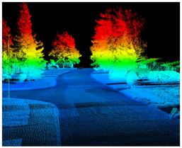
    Point cloud created from a laser scanner with a ground-based point-of-view.

  • Point Cloud image

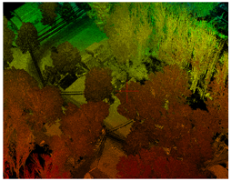
    Point cloud created from a laser scanner with an air-based point-of-view.

  • Mobile laser scanner image

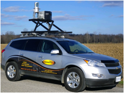
    A mobile laser scanner mounted on an automobile.

  • Feature classification from a raw point cloud.

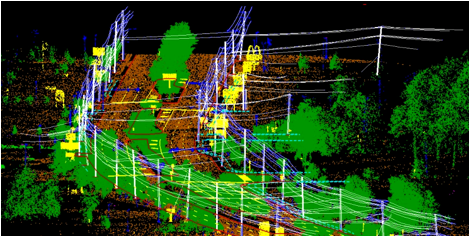
    Mapping infrastructure and vegetation using a point cloud derived from a ground-based scanner.


Team Members

Emmanouil Anagnostou, Professor of Civil and Environmental Engineering, University of Connecticut.

Dave Wanik, Assistant Research Professor, Department of Civil and Environmental Engineering, University of Connecticut.

Tom Meyer, Associate Professor, Department of Natural Resources and the Environment, University of Connecticut.

Wei Zhang, Assistant Professor, Department of Civil and Environmental Engineering, University of Connecticut.

Chandi Witharana, Research Assistant Professor, Natural Resources and the Environment, University of Connecticut.


Contact Information

For more information, please contact Chandi Witharana (chandi.witharana@uconn.edu) or Dave Wanik (dave.wanik@uconn.edu)

Members of the media, please contact Center Manager Malaquias Pena (mpena@uconn.edu) directly.


Eversource Energy Center | Innovation Partnership Building: 159 Discovery Drive, Unit 5276, Storrs, CT 06269-5276 | E-Mail: eversourceenergycenter@uconn.edu