Mapping Tree Risk and Forest Health
Connecticut ranks among the top 13 states in the nation for amount of forested land area with 55% of the state. An additional 20+% enjoys the beauty of urban tree canopies. Within Connecticut’s 149 towns, through the diverse and trecovered regions of the state, including private lands, public open space and conservation areas, Eversource maintains nearly 17,000 miles of overhead electric distribution lines.
Remote sensing technology allows utilities and researchers to observe and collect data on the whole land area within their purview. Laser scans, from aircraft-mounted sensors, can create a 3-D image of the earth’s surface, giving us information including tree locations and canopy heights in addition to more traditional aerial imagery. Among other things, maps made with combinations of these technologies can help us see where forests pose the greatest risk to infrastructure should a storm hit.
UConn’s remote sensing research team is studying effective, large-scale, automated assessments of roadside forest characteristics as well as utility infrastructure. Areas of greater risk to public safety or reliable power can be prioritized in Eversource’s vegetation management efforts.
For the majority of eastern and northwestern Connecticut towns (86), we are using aerial light-detection-and-ranging (LiDAR) scanners to create a 3-D map of vegetation in proximity to utility infrastructure. We are looking specifically in great detail at Greenwich, Connecticut, as part of our 3-D imaging for modernization study where we capture 20-100 points of data in each square meter of land space. In addition, the 3-D image data becomes an input to our Outage Prediction Modeling reflecting local roadside vegetation conditions.
Eversource also works closely with communities and forest practitioners to develop sustainable and storm-resistant forest management practices that preserve the regions character and the myriad benefits of the forest, while mitigating the risk to infrastructure.
Project Goals and Updates
The purpose of this mapping research is to help the public and utility companies most optimally manage their roadside trees and forests to increase storm resistance, thereby reducing weather-related power outages. It will also feed more information to the UConn Outage Prediction Model, helping to increase accuracy of predictions of outages during storm events. The specific goals for this project are:
- To map locations where tree failures could pose a threat to power lines and create a map showing the risk of tree failure at any given location within the state (the risk for a given area will be based on the number of trees within striking distance of utility lines).
- Investigate the potential environmental factors that make trees more prone to failure during storm conditions
- Investigate the effectiveness of Standard Maintenance tree trimming regimes and Enhanced tree trimming on rates of outages
- Create a geo-spatial decision support tool that will allow land managers, community leaders or utility personnel to see the various factors (both social and environmental) that effecting the suitability of an area for Stormwise forest management, tree trimming, tree planting, or other form of intervention to mitigate the threat to infrastructure from vegetation while preserving the aesthetic and ecological functionality of the roadside forest.
We have completed to date:
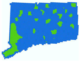
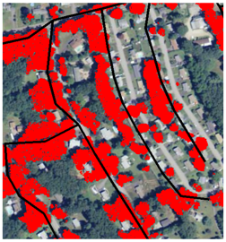
- The accuracy of utility line maps is being improved town-by-town for the state of Connecticut. LiDAR data for the whole state has been processed. Using these two ingredients (location of infrastructure and a 3-D map of vegetation), maps of “proximity pixels” have been created for 40 towns. A proximity pixel denotes an area where the trees are high enough and close enough to strike infrastructure in the event of a tree failure.
- Eversource’s vegetation management and outage records are being used in combination with data about the land, gathered from a variety of sources including scans and video from a small fleet of drones, to identify the characteristics of areas that have had power outages in the past. These characteristics will be used to identify similar areas which have the potential for outages in the future.
- The analysis of the effect of Enhanced Tree Trimming (ETT) has been completed. ETT has been found to reduce the incidence of outages by 35-150% as compared with standard maintenance trimming. The methods that were developed for this analysis will be used to assess standard trimming and resilience upgrades including wire types.

- Connecticut ranks 13 in the nation in terms of percent forest cover and fourth in terms of population density.
- Fifty five percent of Connecticut is currently considered forest and an additional 20 percent of Connecticut is covered by urban tree canopies.
- Trees growing in wetlands, rocky or shallow soils have shallow roots and are prone to uprooting.
- Trees in rocky or shallow soils have shallow roots and are prone to uprooting.
- The forests in Connecticut today began growing in the late nineteenth century after agricultural land was abandoned and large-scale charcoal production ceased.
- Connecticut’s forest today is taller, more expansive, and more mature than it was at the time when much of today’s utility infrastructure was built.
- Forest cover has greatly expanded in Connecticut over the past 100 years in a largely unmanaged manner, resulting in many cases in tall thin trees.
- New or recently trimmed forest edges may be less stable until the newly exposed trees adjust to the greater wind exposure.
- Eversource trims around all power lines in its service area once every four years.
Team Members
- Jason Parent, Assistant Research Professor in the Department of Natural Resources and the Environment, University of Rhode Island, leads the project task
- John Volin, Executive Vice President for Academic Affairs and Provost, University of Rhode Island
- Chandi Witharana, Visiting Assistant Professor, Department of Natural Resources and the Environment, University of Connecticut
- Zhe Zhu, Assistant Professor in the Department of Natural Resources and the Environment, University of Connecticut